View from Oban Bothy

View from Oban Bothy

Thursday, 24 January 2013

24th January, A low noise receive aerial


Modern electronic equipment is the curse of the radio enthusiast. The amount of interference generated by computers, television sets etc, is enough to flatten weak radio signals. The RF crud generated by normal household electronics is strong enough to completely wipe out radio reception. Even seemingly innocent kit can cause problems: some mobile phone battery chargers, some low energy lamps, the dreaded BT wireless hubs, the awful PLA/PLT 'data-over-mains' devices, switched mode power supplies, plasma TVs (these really are bad news), the list goes on and on.

For those who aren't radio enthusiasts but live in an urban environment, you can get an idea of how bad this interference is by tuning around on an AM radio, indoors, in the evening. You'll probably hear plenty of radio stations, but you'll also hear lots of whistles, heterodynes, buzzes, mushy noises etc, that shouldn't be there. Put your AM radio next to a (switched on!) PC or TV and I'd be surprised if you can hear ANY broadcast stations.

It's a legal requirement that electrical / electronic equipment shouldn't cause radio interference - but trying to enforce the law is far easier said than done. There's a huge amount of kit for sale on the high street today that's illegal - it just doesn't meet the RFI / EMC regs. Such is the influence and power of large corporations, they very often hide behind their product's 'CE' marking. I could go on about illegal 'CE' markings....but I wouldn't want to bore you.

This is all bad news for me, I've not been able to play radio for a while. I've experimented with different aerials with varying degrees of unsuccessfulness.

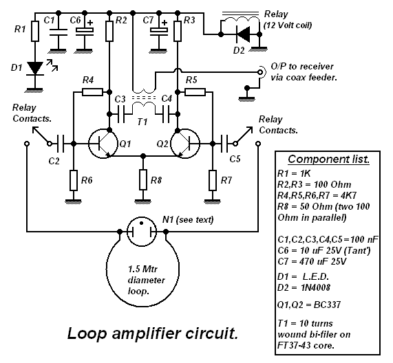
My first major attempt at quiet radio reception was this active, untuned loop. The circuit and notes are published on the QSL.net website of Des, M0AYF - and very good it is too. Thanks Des!

This is the circuit diagram:

Loop amplifier circuit diagram.

The active loop aerial is situated about 35-40 ft down the garden, mounted at around 6ft above ground level.

It's certainly better than my 80m dipole on receive but it's still susceptible to picking up man-made noise - although at generally lower levels. I find it pays to switch between aerials to see which receives less noise - sometimes the dipole wins

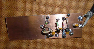
My latest attempt at reducing received noise is this little piece of kit I put together this evening using bits from my junkbox:


This is the ENTIRE antenna - apart from it's power supply. The aerial bit is the plain bit of board on the left, the electronics on the right is a buffer amplifier that matches the extremely high impedance of the small aerial to the low impedance input of the receiver - it provides a significant amount of gain too.

It receives power down it's coaxial cable, and with a little bit of filtering at both ends, there is no need for batteries or separate power feed cables. 

It's tiny - and it seems to work quite well. Although received signals are down on the dipole, received noise levels are WELL down = much easier to copy weak signals that would otherwise be swamped by man-made interference.

It's an E-Field probe so it receives RF by capacitive coupling to the electric field rather than a magnetic field.
 
There is good evidence to suggest that the magnetic component of interfering domestic sources such as TV line time bases tends not to be significantly confined within a building whereas the electric field tends to be significantly attenuated by the structure. This can work to the advantage of this small aerial if it's mounted at a reasonable height and clear of mains wiring & buildings.
I can't claim any originality for this idea, it's the brainchild of Roelof Bakker, PA0RDT - quite a whizzkid by all accounts, and my thanks go to him.

Details of the aerial are widely published on t'interweb but I settled on the article published on the Crawley Amateur Radio Club's website and my thanks go to them also.

Tomorrow, time and weather permitting, the aerial will be mounted remotely down the garden.

Perhaps lower noise radio-activity will return to Timperley soon.

Monday, 21 January 2013

Safeguarding the future of our National Trails

An email from the LDWA popped into my inbox t'other day informing members of a campaign being conducted by the Ramblers. I think it's important enough to reproduce here:

Dear All
The Ramblers have an on line petition about the future management of National Trails and to make sure that National Trails remain our national treasures.
If you enjoy using the trails do click the link below for more info and to sign the Petition.
http://www.ramblers.org.uk/england/campaign-with-us/campaign-for-national-trails.aspx

You know it makes sense….you know what to do.

Sunday, 20 January 2013

20th January, Alderley Edge in the cold

Plans for an active weekend were well and truly scuppered, all down to my responsibilities as a carer. No matter how much planning I do, unexpected situations crop up and bite my bum – this weekend TWO separate incidents conspired to sabotage my plans. An excellent Tally-Ho! run was missed yesterday, and a 17 mile LDWA walk was missed today.
I needed to get out for a bit of a stretch and Alderley Edge seemed to fit the bill – not flat (not very lumpy either!) and fairly close to home. Ten minutes with a map I had a route planned, 8.5km of footpaths and quiet lanes.
Leaving the car at the Alderley Edge National Trust car park I wandered off south(ish), first following the icy lanes through woodland and then on footpaths over Finlow Hill and Clinton Hill.
P1010212 Towards Clinton Hill
P1010214
Looking SW from the saddle twixt Finlow and Clinton Hills, Jodrell Bank in the distance
The footpaths, covered in compacted snow, were slippy – but the tarmac was absolutely treacherous. Ice-rinks had nothing on this. It was good to get off the tarmac and back onto footpaths which generally offered less slippy options.
P1010215Wrapped-up goat….well it IS winter
P1010216
Chilly sheep
P1010217
En-route to the edge
Alderley Edge is home to many of the rich & famous, footballers seem to find it a particularly attractive place to live. The high fences and walls that these houses hide behind make it all but impossible to get a decent photograph of them, so I borrowed this photo from The Daily Mail:
imageThe photo was taken in summer. Obvious innit.
I trundled off northwest-ish to skirt the village (?) of Alderley Edge and then to the sandstone edges. The views were wintry to say the least:
P1010218P1010220P1010221About two hours after setting out I arrived back at the car for a very welcome coffee, it had been too damned cold to stop for a drink on the way round.

8.5km with not much up and downery, but it was good.

Alderley 5 mile route

Thursday, 17 January 2013

Wednesday, 16 January 2013

Police warning…

Do not to throw pies snowballs

Our North-East correspondent may not be aware of this police warning spotted in this morning’s Independent and other newspapers – the warning was even broadcast on BBC R4.

He’ll need to behave. That doggy too. These people mean business.

It’s not called Crook for nothing you know.

Monday, 14 January 2013

12th January, A Burwardsley Bimble

The combination of my recent Sandstone Trail post and reading about Martin’s New Year’s Day walk re-kindled my interest in the area.

It was a chilly morning, between 0 and 2degC according to the car’s thermometer. Leaving the car on the large layby on the A49, just south of the village of Tiverton, I sauntered off to Beeston Castle, preferring to use the quiet lanes rather than the very muddy footpaths. The route south was to broadly follow that of the Sandstone Trail.
P1010174
Beeston Castle
Circumnavigating Beeston Castle we headed off south in the direction of Peckforton Castle – which isn’t really a castle at all, but a country house hotel built in the mid-nineteenth century.
P1010175Peckforton Castle
En-route to the Peckforton Hills: a rather attractive house:
image
P1010180 Welcome to Peckforton
A coffee & butty stop was enjoyed in the woodland of the Peckforton Hills, there wasn’t a breath of wind…and it was cold. There were quite a few walkers and runners out, some were quite mud-splattered – a warning of what was to come.
Leaving this pleasant lunch spot we soon came across a particularly muddy path. We were hemmed in by an electric fence but armed with PacerPoles I was able to safely cross the fence by holding it out of the way of my sensitive bits with the pole handles.
To the west of Peckforton Point the footpath went through the ‘interesting’ grounds of what appeared to be some sort of gate-house:
P1010187  P1010189The R.o.W. goes through this archway!
 
Soon it was time for a change of direction. Entering Higher Burwardsley from the south we headed NNE along the Eddisbury Way which starts here and ends 16.5 miles away in Frodsham – which just happens to be the start (or finish) of the Sandstone Trail. It just goes a different way.
About here the gloopy muddiness really began. Dry stretches of tarmac and good footpaths had been enjoyed up until this point.
The first muddy field was bad enough. It was made doubly tricky by a very inquisitive horsey that was determined to explore the contents of my rucksack. Slipping and sliding down to the field exit and dry tarmac we thought our troubles were over….until this:
P1010193There wasn’t really an alternative so it was just a matter of getting on with it. To the top left of this photo you might just be able to see a rather grand house. It wasn’t until I got closer that I realised just how grand it was:
P1010195It seemed that some paths around he building had been diverted. We struggled to follow the diversions, probably because of the muddy fields. Eventual escape came with the appearance of the tarmac of Wood Lane and the chance to clear crud from suffering boots.
Another coffee stop offered a nice view of both Beeston & Peckforton Castles:
P1010198Shame I didn’t have the decent camera with me, the titchy one didn’t really do the view justice.
Crossing the Crewe – Cheshire railway line at Ford Lane on the Bishop Bennet Way (ask Martin, he’ll tell you all about it), the route continued north to join the muddy towpath of the Shropshire Union Canal which was followed east (east is good) back to Tiverton.
Whilst enjoying a final coffee stop (and I needed to strap up my poorly knee) across from the Shady Oak pub I spotted a peacock strutting around. The light was fading so the picture isn’t brilliant. And the damned thing refused to pose:
P1010201Final approach passed the now closed Beeston Castle Hotel. It’s always sad to see a decent pub close down. I recall it being a bit of a posh place but the beer was good. Ho hum.
P1010205P1010206
The light was really fading and it was getting quite cold by the time I arrived back at the car. Still, it had been a pleasant day out in an area that I’d not explored for a couple of years.
And it hadn’t rained.


Around 11 miles (‘cos of the footpath diversion) with 800ft of upness. It was good.
Beeston route

Friday, 11 January 2013

9th January, The Trans Pennine Trail

….well bits of it

It was Rick’s fault. We’d pencilled-in a walk from Stockport for the day but Rick’s bits were causing him aches and pains so it was agreed to postpone the expedition.
An email popped into my inbox suggesting a walk with the Blackshaws of Timperley. They had this plan, to travel by bus from Altrincham to Warrington and then, using part of the Trans Pennine Trail, walking back to Timperley . 14 miles she said.
Recent experience has led me to come to the conclusion that I’m really quite gullible and easily duped….so I didn’t question the distance and I agreed to tag along.
At 09.30 the No38 bus set off westwards, the talkative driver regaling us with tales of his days in the army. By the time we arrived in Warrington we knew the ins and outs of accurately firing machine guns, long distance yomping and it’s effect on knees and all manner of other stuff.
Suitable educated, we set off westwards (which isn’t eastwards). The first half mile was spent walking in a sort of spiral route….our leader was in search of a loo and she wasn’t about to spend a penny in order to spend a penny. It’s being careful with money she says.
It was well past 11am when we eventually left Warrington. West at first, passing the very ornate gates to Bank Hall that dates from 1750. The building now houses the Town Hall.
P1010116Bank Hall – now Warrington Town Hall
Then passing this war memorial to those who lost their lives in two world wars:
P1010118P1010119The Joseph Crosfield & Sons war memorial  
Joseph Crosfield was a Quaker and a successful local business man. His business manufactured soap and chemicals.
Onwards and westwards,,,,then southwards, crossing a railway line at Monks Siding. The line links Liverpool with Manchester and seems to be used mainly for freight. This area was once very heavily industrialised and the line was much busier in earlier times.
Following the River Mersey in the misty murk didn’t afford any decent views:
image It wasn’t raining although it was damp and cold and I was glad to be wrapped in my Velez, I didn’t take it off until I arrived home.
P1010126
Arpley Meadows sign gives an idea of how far we’ve got to walk. .
A rather damp wooden bench seat appeared as we walked through Arpley Meadows – we didn’t need to ask. A pleasant stop for coffee and cake was most welcome, we came across one of the very few walkers of the trip – a Lymm man who had dropped his car off for a service and was using the time to explore the area.
Passing Morley Common and heading towards Wilderspool we came across the disused Runcorn & Latchford Canal. Bits and pieces of machinery in remarkably good condition are still in evidence here although the old lock gates have seen better days.
P1010131
P1010133
Maritime mangles?
P1010134
Lock gates
Builders at the pretentiously named Stockton Pointe construction site didn’t want cylclists cylcling close to their site. The cylclists may well have fallen off their bicylcles when they saw this sign:
P1010143Heading in a very definite easterly direction along the banks of the Manchester Ship Canal.
P1010144
Crossing the canal by the old swing bridge at Knutsford Road (the A50) marked a change in flavour of our route.
P1010146 The Blackshaws, desperately trying to shake me off.
We were now walking on tarmac for the next mile or so, passing a fine example of Victorian construction:  the now disused railway bridge at Latchford:
P1010147
Next came Latchford Locks – although they looked to be in good condition I can’t imagine them being used much these days.
P1010149 Latchford Locks
P1010154
A relic from busier times
Onwards and most definitely eastwards we left the Manchester Ship Canal behind and joined a disused railway line that ran between Liverpool and Altrincham. This section of the T.P.T. runs through Thelwall (famous for it’s wall of thells) and  Lymm (famous for Sooty & Sweep) before crossing the River Bollin (famous for, er, something).
We didn’t follow the T.P.T. as far as Lymm, preferring to divert to the Bridgewater Canal towpath for the short stretch into Lymm….and to show Steve where Sooty & Sweep live. Steve’s led a sheltered life.
Once Steve had been suitably educated and we’d enjoyed a quick butty & coffee stop, we rejoined the T.P.T. disused railway line to walk through Heatley. Hats were doffed as we passed the site of the the much-missed Railway Hotel (a listed building) that mysteriously burned down in 2011. It was so fortunate that there was a JCB parked very locally at the time of the fire. The site is now fenced-off, no doubt awaiting the arrival of a new housing estate.
Around here the T.P.T. passes through farmland – much of which was suffering from the recent high levels of rainfall – heaven knows how high the water table is.
P1010162     
Wet Gate Lane Farm. Famous for being wet.
Steve’s plan was to once again leave the T.P.T., this time just before Dunham. We followed footpaths that crossed muddily slippy fields, eventually delivering us to The Vine in Dunham (Sam Smith’s). Light was fading so we deemed it prudent to pass the pub and continue to Dunham Park. En-route to the park we spotted an interesting variation on environmentally friendly transport….perhaps as green as it gets:
P1010164Dunham Park was emptying as we arrived, just before 4pm. The convenient conveniences and convenient bench seats made for a convenient last coffee stop on our little walk.
P1010168
A Dunham resident
The light was fading fast now and the temperature was falling. Leaving the park we crossed over Charcoal Lane to scoot across the rather posh golf course. We’ve walked across this golf course many times before (there ARE public footpaths across it) but the gathering darkness had us quite confused. I’m easily confused.
Eventually we escaped to cross the A56 to walk through the Devisdale and past Denzell House. We couldn’t resist a quick smirk as we passed the offices with people still beavering away at their desks.
P1010170Denzell House 
The Devisdale in the dark is a completley different place to it’s daytime companion – but somehow we managed to navigate our way across. Exiting in Altrincham it was then just a couple of miles of tarmac to home.
The ‘fourteen miles’ ended up being 19 miles when the walk from home to the bus station was taken into account. I did tell you that I’m gullible. Ask anyone.
image …and this is where we went.
It was a good day – if a little longer than I expected, although it certainly wasn’t an excessive distance. The ascent was negligible….around 200ft. Not a lot.

Lyme Park to Buxton, 18th July 2024

  A text message from my mate Vinny suggested we might go for a bit of a walk, he quite fancied Lyme Park to Buxton. It promised to be a ...